Posts

Sandy’s Teachable Moment on Infrastructure

In a remarkable development, the devastation from Sandy now is finally moving a least a portion of the national conversation onto the very important topic of infrastructure and how we need to renew our degrading infrastructure in addition to hardening it against new waves of damage due to weather extremes brought on by climate change. Consider this bit of truth-telling from Connecticut Governor Dannel Malloy on Rachel Maddow’s show last night:

But it’s not just Malloy who sees the need to have the future in mind during the recovery from Sandy. Today’s New York Times carries an article in which New York Governor Andrew Cuomo discusses how preventive steps need to be taken in the near future:

On Tuesday, as New Yorkers woke up to submerged neighborhoods and water-soaked electrical equipment, officials took their first tentative steps toward considering major infrastructure changes that could protect the city’s fragile shores and eight million residents from repeated disastrous damage.

Gov. Andrew M. Cuomo said the state should consider a levee system or storm surge barriers and face up to the inadequacy of the existing protections.

“The construction of this city did not anticipate these kinds of situations. We are only a few feet above sea level,” Mr. Cuomo said during a radio interview. “As soon as you breach the sides of Manhattan, you now have a whole infrastructure under the city that fills — the subway system, the foundations for buildings,” and the World Trade Center site.

The Cuomo administration plans talks with city and federal officials about how to proceed. The task could be daunting, given fiscal realities: storm surge barriers, the huge sea gates that some scientists say would be the best protection against floods, could cost as much as $10 billion.

It is sad that such a level of devastation is needed before there is talk of action. As recently as last month, the Times carried yet another warning that exactly this type of damage was becoming increasingly likely:

But even as city officials earn high marks for environmental awareness, critics say New York is moving too slowly to address the potential for flooding that could paralyze transportation, cripple the low-lying financial district and temporarily drive hundreds of thousands of people from their homes.

Only a year ago, they point out, the city shut down the subway system and ordered the evacuation of 370,000 people as Hurricane Irene barreled up the Atlantic coast. Ultimately, the hurricane weakened to a tropical storm and spared the city, but it exposed how New York is years away from — and billions of dollars short of — armoring itself.

“They lack a sense of urgency about this,” said Douglas Hill, an engineer with the Storm Surge Research Group at Stony Brook University, on Long Island.

Instead of “planning to be flooded,” as he put it, city, state and federal agencies should be investing in protection like sea gates that could close during a storm and block a surge from Long Island Sound and the Atlantic Ocean into the East River and New York Harbor.

And it was exactly that storm “surge from Long Island Sound and the Atlantic Ocean into the East River and New York Harbor” that flooded lower Manhattan and the New York subway system. Considering that estimates yesterday on the financial impact of Sandy were already going as high as $25 billion (and I expect that number to go up by a lot as more damage is discovered), an investment of $10 billion for a surge barrier, coupled with a massive push for revitalizing and hardening the electrical and transportation systems behind the barrier, looks like a very wise investment. Sadly, though, as Malloy points out, half the country doesn’t believe in infrastructure investment. At least, that was the case before Sandy. Will infrastructure scrooges who were directly impacted by the storm finally see the importance of being proactive, or will yet another teachable moment be lost?

Sandy Makes Turn, Landfall in Mid-Atlantic Expected by Monday Night

In the 8 am update from the National Hurricane Center, NOAA has announced that Hurricane Sandy is now moving to the north-northwest. In the previous update, Sandy was headed due north, so this means that the turn toward the coast of the US has begun and the expected track leading to landfall along the Delaware or New Jersey shoreline remains in place. There are many dire predictions that have been made for this storm, so I will not repeat all of them here, but I do want to emphasize some of the most important pieces of information from the latest update.

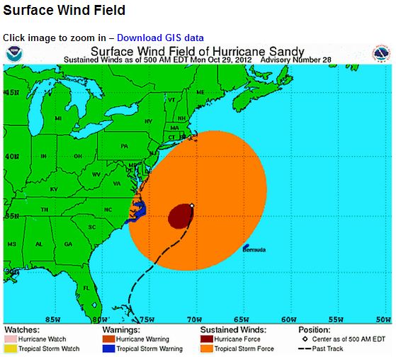
The graphic above, which is from the 5 am update, shows the sheer size of the storm very effectively. The current wind field has tropical storm force winds already along the coastline from North Carolina through Massachusetts. In the Public Advisory portion of the 8 am update, we learn more about the storm’s size:

HURRICANE-FORCE WINDS EXTEND OUTWARD UP TO 175 MILES…280 KM…FROM THE CENTER…AND TROPICAL-STORM-FORCE WINDS EXTEND OUTWARD UP TO 485 MILES…780 KM.

That means that the red oval of hurricane force winds in the graphic has a diameter of 350 miles. In other words, a 350 mile stretch of coastline is due to receive hurricane force winds. Similarly, the orange oval of tropical storm force winds has a diameter of 570 miles, an almost unheard of size for a storm anywhere on the US East Coast.

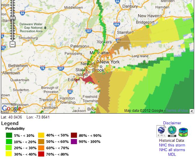
Besides the expected wind damage, though, this storm is likely to produce very significant storm surge flooding. At this link, NOAA allows the user to plug in a selected storm surge height and then see the probability of the surge exceeding that value. I plugged in a five foot storm surge and got the following map:

The five foot storm surge is important, because that would be the level at which it is possible that water could begin to flood the New York subway system, which would be estimated to cause billions of dollars in damage. From Jeff Masters at Weather Underground (emphasis in the original):

Sandy is now forecast to bring a near-record storm surge of 6 – 11 feet to Northern New Jersey and Long Island Sound, including the New York City Harbor. This storm surge has the potential to cause many billions of dollars in damage if it hits near high tide at 9 pm EDT on Monday. The full moon is on Monday, which means astronomical high tide will be about 5% higher than the average high tide for the month. This will add another 2 – 3″ to water levels. Fortunately, Sandy is now predicted to make a fairly rapid approach to the coast, meaning that the peak storm surge will not affect the coast for multiple high tide cycles. Sandy’s storm surge will be capable of overtopping the flood walls in Manhattan, which are only five feet above mean sea level. On August 28, 2011, Tropical Storm Irene brought a storm surge of 4.13′ and a storm tide of 9.5′ above MLLW to Battery Park on the south side of Manhattan. The waters poured over the flood walls into Lower Manhattan, but came 8 – 12″ shy of being able to flood the New York City subway system. According to the latest storm surge forecast for NYC from NHC, Sandy’s storm surge is expected to be at least a foot higher than Irene’s. If the peak surge arrives near Monday evening’s high tide at 9 pm EDT, a portion of New York City’s subway system could flood, resulting in billions of dollars in damage. I give a 50% chance that Sandy’s storm surge will end up flooding a portion of the New York City subway system.

Unfortunately, the 8 am NHC advisory contradicts Masters on the point of only one tide cycle being affected by the storm surge:

ELEVATED WATER LEVELS COULD SPAN MULTIPLE TIDE CYCLES RESULTING IN REPEATED AND EXTENDED PERIODS OF COASTAL AND BAYSIDE FLOODING.

One last bit of bad news from NOAA is that Sandy could still strengthen somewhat:

REPORTS FROM AN AIR FORCE HURRICANE HUNTER AIRCRAFT INDICATE THAT THE MAXIMUM SUSTAINED WINDS REMAIN NEAR 85 MPH…140 KM/H…WITH HIGHER GUSTS. SANDY IS EXPECTED TO TRANSITION INTO A FRONTAL OR WINTERTIME LOW PRESSURE SYSTEM PRIOR TO LANDFALL. HOWEVER…THIS TRANSITION WILL NOT BE ACCOMPANIED BY A WEAKENING OF THE SYSTEM… AND IN FACT…A LITTLE STRENGTHENING IS POSSIBLE DURING THIS PROCESS. SANDY IS EXPECTED TO WEAKEN AFTER MOVING INLAND.

The next several days will be trying for the Mid-Atlantic area. I urge everyone in the region to listen carefully to local emergency managers and to follow their guidance.