
Not-So-Casual Water: Insurance Fraud Alleged at Trump-Westchester
[NB: Check the byline, thanks. /~Rayne]
Hope you were able to get out on the links this weekend if you’re a golfer and your local weather was good. The season here in Michigan is wrapping up this week or next from the looks of things.
Wonder when the course will close at Trump National Golf Club Westchester this year, if it hasn’t already?
Rolling Stone published another piece about the course; this time ex-employees dished about insurance claims made related to flooding at the course in 2011.
Recall that Trump reported in FEC financial filings that Westchester was worth an estimated $50 million.
Trump org fought with the local tax authority, insisting the course should have an assessed value of $1.4 million — much lower than the fire sale price of $7.5 million Trump paid for the course in 1996 when it went into foreclosure.
But the former insiders said Trump org claimed a loss of $1.3 million due to flooding in 2011.
There’s no indication at all that the golf course’s business was disrupted by the flooding, which one might think was likely if half or more of the course had been so badly damaged.
The local municipality sued Trump because of damage caused by changes to his course which disturbed water flows. It’s pretty obvious from a Google Maps terrain view that the water flows toward the municipality of Briarcliff from the Trump course so Trump and his organization can’t say they couldn’t have anticipated a problem in the event of heavy rains.
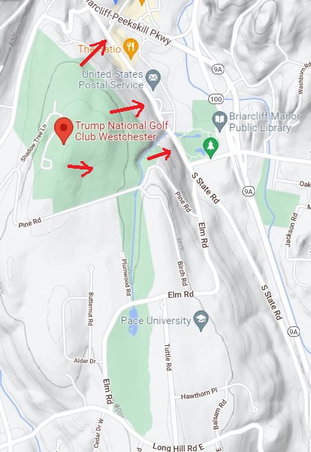
That top red arrow points to the area nearest the intersection of Pleasantville Road (Nw to SE, east side of course) and State Road (ends at Pleasantville Road, runs NE to SW). Google Streetview images show the street surface on State Road near the intersection has been repaired and worked over at some point since 2009.
If you’re just Joe Duffer out on the course, you can see the manufactured water features — specifically two waterfalls denoted by red arrows — which must rely on water level being artificially maintained along with drainage in case of overflow. The creek and wash area have two feature cart bridges over them under which excess water should flow east in the direction of the red arrow. The waterfalls aren’t attractive unless the water is kept up high which means any extra water from surfaces like parking lots and fairways draining toward the pond will overflow rapidly into a wash which ends…????
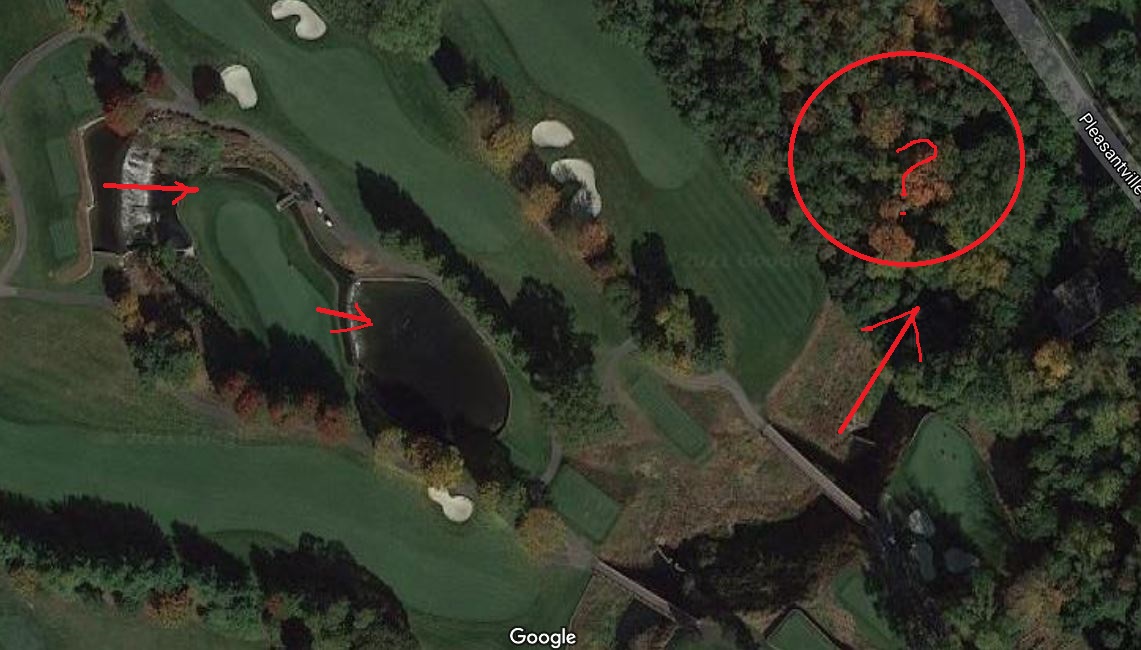
Somewhere under Pleasantville Road I hope there’s a big drain.
On the east side of Pleasantville Road is the Walter M. Law Park and the Briarcliff Manor Public Library. The park includes tennis courts, a swimming pool, a baseball diamond, and a pond which looks like it might be fed from water coming from under Pleasantville Road.
In 2011, floodwaters damaged the park area, causing heartburn for the local municipality:
The dispute began not long after a series of storms on June 23, 2011, dumped 5 inches of rain on the region. Waters swamped the village’s Law Memorial Park swimming pool and deposited silt about a third of a mile from the course, next to the Briarcliff Manor Public Library. Also flooded were the playing fields behind the swimming pool, where a geyser gushed from a manhole whose cover popped up from the drainage system blockage.
Briarcliff Manor met with Trump org several times about the damage and reparation. After hashing over the problem fruitlessly it billed Trump org $238,000 for the damage done because Trump’s course had made “unauthorized alterations” to the watercourse which elevated the waterfall ponds’ levels by up to six feet. Trump org denied doing anything to cause the problem, leaning into the argument that the rain was an unanticipated 300-year flood event.
Neighbors of the golf course were further upset by Trump’s balking at the property value assessment when Trump org argued the course owed only $47,000 and not $470,000 based on the much lower property value of less than $2 million.
That lower property tax amount is audacious considering Trump’s financial henchman Alan Garten claimed the flooding of the public park occurred because “…a drainage pipe under the village fields was clogged. It was clogged because the village [Briarcliff Manor] was too cheap to put up a grate to prevent rocks and boulders from coming in.”
(Where would the money come from, Garten? Tax revenues?)
What was it, then, the Trump org claimed against its insurance coverage compared to what they paid? Were the claims under investigation in relation to the 2011 flooding? Were they also in relation to more recent flooding due to high water levels from Hurricane Ida in August this year?
Or were there other claims we don’t know about yet?
What were the real terms of the settlement Trump org made with the local taxing authority, the Ossining Board of Assessment Review, when the Rolling Stone said,
The Trump Organization ultimately paid the town $50,000 to settle the lawsuit but, under the terms of the settlement, did not admit any wrongdoing, according to a copy of the settlement obtained in a request made under New York’s Freedom of Information Law. The settlement came on July 12, 2016, a few days before Trump accepted the Republican nomination for president.
50 grand seems suspiciously light when the engineering analysis to assess the problem and determine a solution likely cost the municipality more than that amount.
The timing is even more suspicious — how convenient the problem was resolved right then, before Trump’s campaign began in earnest.
The specifics of the agreement remain a mystery which seems to be par for this course and Trump’s organization.


Jesus Christ. How did I not know Dan Scavino started working at the Westchester course in 1990 as a caddie. Trump didn’t buy the course, though, until 1996 when the course went into bankruptcy.
I wonder if anyone ever checked that stream course under the trees between the course and the road – I’d bet it was clogged with stuff from the course as well as from the trees. And the drain under the road would need to be checked and cleaned, which isn’t cheap.
Lol, like in New Orleans where they finally went to clean out a main sewer line and found multiple cars – yes cars – plugging it that had likely been there for a very long time.
Some of the storm drains in my area have covers that are (heavy) sheet metal with half-inch holes – they’ll catch most leaves as well as larger objects, the kind that would go through the usual two-inch-spacing gratings.
I’d expect golf balls in the one there.
(For things in storm drains: Lois McMaster Bujold’s “Weatherman”)
I’d sure like to see the 1996 existing conditions plan and the grading plan for Trump’s “improvements.” I’ll bet they graded the heck out of that topo so that 100% of the run-off went to other’s properties. I can’t imagine Trump absorbing the cost to treat/redirect/channel stormwater.
Looks like it’s on top of a ridge, so all the runoff goes Elsewhere.
Yes, but what was the original configuration of the ridge? It could be entirely trump’s by design. At the very least, they have to contain a portion of the run-off, and I’m guessing they actually intentionally directed it elsewhere. There are ways to work this out among APOs — happens every day.
If you look at Google Maps Terrain in Layers, https://goo.gl/maps/JgSEojwLnM1dmQNV8 you’ll see the large uppermost pond closest to the clubhouse was already at the highest elevation in the area and located on the edge of the ridge. To increase the drama of the falls, all Trump org would have to do do is ensure the wall over which the water fell was high and add some fill around the edge of the pond.
I assume from the configuration that water from the lower pond is recirculated back to the upper pond to keep its level high enough to cascade over the waterfall continuously. Because the falls rely on keeping water level constantly high, there’s no containment – it spills over from lower pond into the watercourse over which the two lengthy cart bridges were installed. The excess water flows from west to east toward the village and there’s no obvious drain or waterway for us to follow the water once it leaves the course. The park and library are at what appears to be the lowest elevation in the village. You’d think a responsible business owner who valued community relations would ensure such risks were dealt with preemptively, but no – and I’m wondering what happened to engaging civil engineers during course tweaks.
That’s why the regulatory oversight entity has to hold the permits until the applicant proves compliance with requirements (i.e. containing flow, providing adequate public infrastructure, etc.). This is not difficult!
Unless you’re dealing with someone like Trump who ignores permitting and who files SLAPP suits intended to both slow, obstruct, and punish even governmental participation…
well . . yes. that’s right, Rayne.
There is most likely a culvert under Pleasantville Rd that conveys runoff from the golf course toward the east and eventually to the Pocantico River. Google maps street view shows a grated intake structure at 1000 Pleasantville Rd. I’d guess the storm drain goes under Pleasantville Rd, follows Van Lu Van Rd for a short distance, and then goes east under the parking lot on the south side of Altria Briarcliff Manor. Google Earth historical view from 2002 shows a diagonal area heading northeast toward the river, which is probably the alignment of the storm drain. There should be a drainage easement for the storm drain through the Altria Briarcliff Manor property. The county clerk’s records of the deed for the property might have the easement for the storm drain.
Real-estate agents usually have access to that kind of information. And utility companies. The legal description should include easements.
You can grasp why the village needed that $238,000 for damages based on your description of the water handling. That parking lot at Altria is at the north end of where flooding was described at the ballpark. My guess based on the report that State Road was damaged is that the drain ran further north as well and may have caused the road to heave/collapse.
Definitely on top of a ridge. During summer with trees fully leafed out it’s difficult to discern from Google Maps Streetview but the course is definitely at much higher elevation than the village.
Yup, the course is much higher than the village. The Briar Hall Country Club main building is about 200 feet higher than the stream crossing at Pleasantville Road. It looks like nearly all run-off from both sides of Pine Road flow to that crossing and toward Altria Briarcliff Manor and the Pocantico River as noted by SWS. Overall topography hasn’t changed much but more and larger water features keep appearing over time. Drainage to that one crossing starts at least as far south as the pond near Long Hill Road East which is about one mile away.
“Absorbing the cost….”
Most families absorb the cost of paternal personality disorders as Slaveowner’s past on all the cost 💲 of their operational business models to the slave’s while they reaped the benefits.
Jefferson Davis 101 ?
Many public health laws origins were established to protect clean water from Pig Owners piggeries putrid runoffs from upland sites polluting water with 🐷 dung when it rained. Thing Hurricane..
Nothing has really changed, except for scale. Same scope with much greater moral hazards than animal entrails dumped in Public’s waters by slaughterhouses, as we have 100,000’s of now gone Americans
whose simple use of a mask 😷 would have acted as viable prophylactic against a disease 🦠 like those in the Philippines during WWII?
Yes pitching the pitch has Trump’s Pitch from day one ☝️ of his existence, being all learned behavior.
No different from a Tobacco Commercial, Trump’s “ism” is a “Big Lie.”
Take the acrylic enamel covering off a golf and unwind all the rubber, and the core “ism” is rancid, just like 🐖’s dung.
I was born in America’s armpit, in the “Garden State.”
Never mind the methane..
If it was on the course’s property, Trump org would have “cleaned” the area for the appearance of the course. But appearance and flood control aren’t the same things; if improving appearance meant more silt, rocks, and plant material could be dislodged by heavy rains, the drains could have been quickly clogged.
Play it, as it lies.
good one, punaise!
par for the coarse!
And it lies all the time.
The tax assessment valuation aside, Mayor Vescio seriously needs to take a legal communications 101 class about use of organization emails.
I presume the mayor is not a hydraulics engineer, and had no business writing Trump this “get out of jail free” card:
https://www.documentcloud.org/documents/2394534-2013-06-04-vescio-to-zegarelli.html
That’s what happens when a town or small city has a “strong mayor” form of government.
You can get a more detailed look from the Westchester County GIS site:
https://giswww.westchestergov.com/taxmaps/default.aspx?sMun=BriarcliffManor#
Type in the property address (100 Shadow Tree Ln) and you’ll see the three parcels that make up 98.14-1-1.
Select More Data (upper right) and you can toggle through Flood Plains, Steep Slopes, and 2-ft Contours — this last one requires you to zoom in to get those details. (I wasn’t able to see the Drainage Structures.)
In the Hybrid and Aerial Photo views there is a slider that will show different aerials from 1947 to 2018. Unfortunately, it looks like the Steep Slopes and 2-ft Contours are contemporary only.
A lot of this kind of mapping is newer – it just wasn’t done in the past, because it was hard to do two-foot contours and steep slopes before things like Lidar.
Yep. At the parcel level, traditional topographic contours were almost useless.
For this “project” you can select the hybrid view, zoom in to the fairways and greens, move around, and get a very good idea of the lay of the land — and how steep it is on the east side of the north parcel down to Pleasantville Road. You can also “drive” along with Street View to get a feel for it.
I had a lot of fun at work overlaying USGS quads on aerial photos – it makes the terrain really pop. (I read maps of several kinds. And photos. And work orders. (No, it’s really here!) Got a rep as someone who can Find Stuff.)
good job, raven eye!
The assessor’s roles for the past few years are at:
https://www.townofossining.com/cms/publications/all-documents/assessor/assessment-rolls
I haven’t found an online database — those are large PDF files. But you can download them and then to the search for 98.14-1-1.
True to form.
Trump costs everyone else something
while kicking the ball to a more favorable spot for himself.
Had the tax revenues he paid not been a tenth of what he likely owed,
and the officials not given him the nod and likely a wink
then a whole lot of people would have been better off.
After ten years what worse disasters and profound injury.
tax fraud as populist patriotism, the new GOP
If Trump claimed that his property is worth only $1.4M for tax purposes, why can’t the city buy the property for that reasonable value?
I think I might have threatened with a lien if I worked for the village. But then a SLAPP suit would follow. Always the SLAPP suits.
It looks like several of you have gone over the topos already, and your assessments of where the main drainage goes seem accurate. On the Google Maps view embedded above, there’s one small area ESE of the main pond that, on the photo, appears to be a discolored triangle. I would expect that to be a graded (and very artificial looking) swale for drainage. However, it may have been put there to serve a previous iteration of the pond. From the looks of things, that main pond looks, as Rayne pointed out, to have had its banks raised, to the point that it’s almost like a bathtub rim, and has to be kept very full all the time, in order to keep the waterfall pretty. To the east of the rim, it’s nothing but a steep drop-off, and water flooding over that east side would already be flowing very fast, even after 100′. The flooding hazard to the park and library is obvious.
With that course located on a little hillock, the highest point in the area, and with the major flooding hazard (that pond and particularly the east rim) being nearly on the east edge of the property, I see no way for there to be damage in the hundreds of thousands to have been inflicted on the course. Unless they accidentally left the roof off the clubhouse. When a pond floods, it’s a nasty mess around it, as all sorts of silt and detritus from the pond gets on the land around it. But that’s cosmetic, and should have only cost in the low five digits to clean up.