Sandy Makes Turn, Landfall in Mid-Atlantic Expected by Monday Night
In the 8 am update from the National Hurricane Center, NOAA has announced that Hurricane Sandy is now moving to the north-northwest. In the previous update, Sandy was headed due north, so this means that the turn toward the coast of the US has begun and the expected track leading to landfall along the Delaware or New Jersey shoreline remains in place. There are many dire predictions that have been made for this storm, so I will not repeat all of them here, but I do want to emphasize some of the most important pieces of information from the latest update.
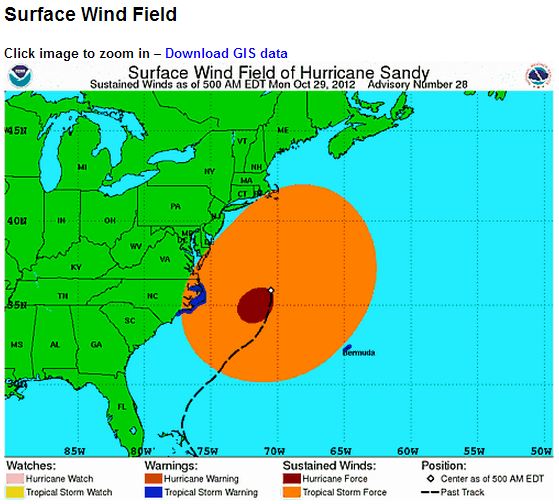
The graphic above, which is from the 5 am update, shows the sheer size of the storm very effectively. The current wind field has tropical storm force winds already along the coastline from North Carolina through Massachusetts. In the Public Advisory portion of the 8 am update, we learn more about the storm’s size:
HURRICANE-FORCE WINDS EXTEND OUTWARD UP TO 175 MILES…280 KM…FROM THE CENTER…AND TROPICAL-STORM-FORCE WINDS EXTEND OUTWARD UP TO 485 MILES…780 KM.
That means that the red oval of hurricane force winds in the graphic has a diameter of 350 miles. In other words, a 350 mile stretch of coastline is due to receive hurricane force winds. Similarly, the orange oval of tropical storm force winds has a diameter of 570 miles, an almost unheard of size for a storm anywhere on the US East Coast.
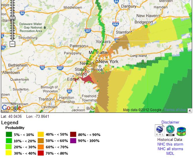
Besides the expected wind damage, though, this storm is likely to produce very significant storm surge flooding. At this link, NOAA allows the user to plug in a selected storm surge height and then see the probability of the surge exceeding that value. I plugged in a five foot storm surge and got the following map:
The five foot storm surge is important, because that would be the level at which it is possible that water could begin to flood the New York subway system, which would be estimated to cause billions of dollars in damage. From Jeff Masters at Weather Underground (emphasis in the original):
Sandy is now forecast to bring a near-record storm surge of 6 – 11 feet to Northern New Jersey and Long Island Sound, including the New York City Harbor. This storm surge has the potential to cause many billions of dollars in damage if it hits near high tide at 9 pm EDT on Monday. The full moon is on Monday, which means astronomical high tide will be about 5% higher than the average high tide for the month. This will add another 2 – 3″ to water levels. Fortunately, Sandy is now predicted to make a fairly rapid approach to the coast, meaning that the peak storm surge will not affect the coast for multiple high tide cycles. Sandy’s storm surge will be capable of overtopping the flood walls in Manhattan, which are only five feet above mean sea level. On August 28, 2011, Tropical Storm Irene brought a storm surge of 4.13′ and a storm tide of 9.5′ above MLLW to Battery Park on the south side of Manhattan. The waters poured over the flood walls into Lower Manhattan, but came 8 – 12″ shy of being able to flood the New York City subway system. According to the latest storm surge forecast for NYC from NHC, Sandy’s storm surge is expected to be at least a foot higher than Irene’s. If the peak surge arrives near Monday evening’s high tide at 9 pm EDT, a portion of New York City’s subway system could flood, resulting in billions of dollars in damage. I give a 50% chance that Sandy’s storm surge will end up flooding a portion of the New York City subway system.
Unfortunately, the 8 am NHC advisory contradicts Masters on the point of only one tide cycle being affected by the storm surge:
ELEVATED WATER LEVELS COULD SPAN MULTIPLE TIDE CYCLES RESULTING IN REPEATED AND EXTENDED PERIODS OF COASTAL AND BAYSIDE FLOODING.
One last bit of bad news from NOAA is that Sandy could still strengthen somewhat:
REPORTS FROM AN AIR FORCE HURRICANE HUNTER AIRCRAFT INDICATE THAT THE MAXIMUM SUSTAINED WINDS REMAIN NEAR 85 MPH…140 KM/H…WITH HIGHER GUSTS. SANDY IS EXPECTED TO TRANSITION INTO A FRONTAL OR WINTERTIME LOW PRESSURE SYSTEM PRIOR TO LANDFALL. HOWEVER…THIS TRANSITION WILL NOT BE ACCOMPANIED BY A WEAKENING OF THE SYSTEM… AND IN FACT…A LITTLE STRENGTHENING IS POSSIBLE DURING THIS PROCESS. SANDY IS EXPECTED TO WEAKEN AFTER MOVING INLAND.
The next several days will be trying for the Mid-Atlantic area. I urge everyone in the region to listen carefully to local emergency managers and to follow their guidance.


excellent graphics.
very informative.
FYI:
death and regulation problems in a hidden part of our economy –
http://www.nytimes.com/2012/10/29/us/on-us-farms-deaths-in-silos-persist.html?hp&_r=0
Noon Monday NOAA surge prediction is 12> feet at NYC.
Here’s the picture that should go side by side with the Mittens clips advocating privatizing disaster response.
http://i.huffpost.com/gadgets/slideshows/259321/slide_259321_1696598_free.jpg?1351519406417
Thanks for this, Jim. We’ve battened down the hatches as much as we can, here. There’s lots of wind now, and already quite a bit of rain. I wonder how much longer we’ll have internet and electricity…
Wish us luck! -harpie
@harpie: Sending you all the positive vibes I can. Be safe, and please let us know you’re okay once things clear and you’re back online.
Irene’s Central Park barometric pressure was 966 mm.
http://blogs.wsj.com/metropolis/2011/08/28/weather-journal-after-irene-clear-skies/
So far today it has reached 978 mm.
ironic that hurricanes have been the ones to expose our leaders as irresponsible clowns
Tally (thus far):
Hurricanes: 1 (Katrina)
Clowns: 0 (Bush)
Raw data (observed water level) from The Battery…
The data suggests things are worse than expected… as in over 12’…
Godspeed Gotham!
ruh-roh… 13.04
I’m seeing several reports now on Twitter that water has entered the subway system and that smoke is pouring out in a couple of places. Very bad news if system is indeed taking on water.
@Jim White: if you’re so inclined, you can listen live to the various NY Fire & Police Dispatches at this link. very addicting. and scary. flooded streets and no way to get to people in trouble:
http://www.radioreference.com/apps/audio/?action=wp&feedId=7392
Water level at the Battery topped out at 13.87 ft at high tide.
There’s four feet of it in the East River subway tunnels.
big time money don’t have much sway in NY at the moment?
best wishes good people.
help each other.
hoping all can be safe and if no power at least be warm and dry.
and(cynical,i know)
a natural comparison opportunity between the response from the current federal administration and the helicopter over rides and boot buying antics from a well known previous emergency.
Yes, it was a nice warm pleasant day, light breeze now and then. Not many clouds. Dry too. Although I did a bit of sweating while working outside next to the house, it was a typical autumn day in the West.
From the NYT, which has wisely offered up free mobile and Internet updates about the storm, including this OpEd:
http://www.nytimes.com/2012/10/30/opinion/a-big-storm-requires-big-government.html
Meanwhile, NYT, Guardian, and Andrew Sullivan have astonishing photos.
Soggy Seattle is looking really good tonight in contrast.